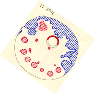
Hut 11 (brewery hut)( Visual Item)
Attached files

Type
Document
Caption
Diagram of Hut 11
File
c77de95c05f7422c87d5b3e9298ca102.pdf
Type
GeoTIFF
Caption
Diagram of Hut 11
File
NewHut11.tif
Description
Diagram 'Hut 11' from Mike Cronin's 1975 Honours thesis 'Mgungundlovu', UCT. High-resolution scan of the thesis supplied by the libraries of the University of Cape Town. The map was drawn by the Department of Archaeology with the Department of Land Surveying. The location of the original map is currently unknown.
Type
Visual Item
Held by
Provenance
None
Spatial
None
Spatial relationships
- Falls within Farm Moordplaats No 193 (Place)
- Falls within Map of Dingaan's Kraal -Mgungundlovu (Visual Item)
- Falls within Isigodlo area, section A (Visual Item)
- Falls within Site map of uMgungundlovu (Visual Item)
- Falls within Map sheet 2831AD (Visual Item)
- Contains uMgungundlovu (Place)
- Contains No title (Human-Made Object)
Makes connections with
- forms part of Mgungundlovu - -- Honours thesis (Mgungundlovu - Honours thesis by M…)
- has former or current location uMgungundlovu (History: From the Ntonjaneni Sprin…)
Archival Status